Archiu:Pestilence spreading 1347-1351 europe.png

Resolució completa. ((1280 × 1387 pixels, tamany de l'archiu: 350 kB, MIME tipo: image/png))
| Descripción |
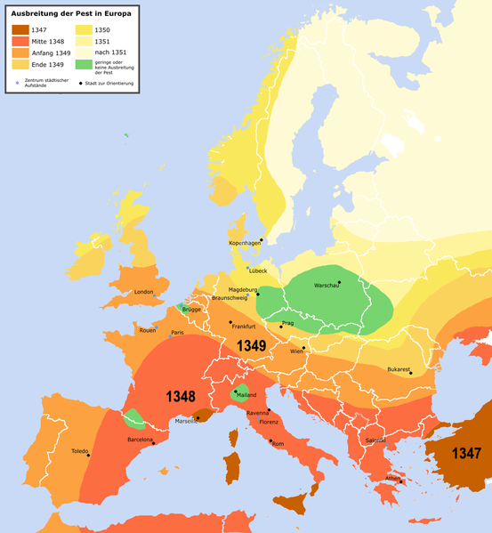
English: Spreading of the en:Black Death in Europe between 1347 and 1351, apparently copied from a work called "Atlas zur Weltgeschichte" (perhaps dtv-Atlas? If so, Kinder and Hilgemann (eds.), dtv-Atlas zur Weltgeschichte was published in 35(!) editions between 1964 and 2002, and it would be crucial to know which edition we are basing this on).
The details of the map are to be taken with a large grain of salt. It is roughly compatible with this Britannica map (copy, dated 1994), but the details vary significantly. Other significant differences exist with this map (an unreferenced scan of a professional publication), where e.g. the area of Poland/Silesia marked "unaffected" in this map is part of a much larger area marked as "Area for which there is insufficient information". Here is another map with a somewhat more conservative epistemology, referenced to "insecta-inspecta.com", where it was posted in 2000 (and therefore uninfluenced by the 2005 upload of this map). An academically published map for comparison: [1] cited to: D. Sherman and J. Salisbury, The West in the World: Volume I to 1715. McGraw-Hill, Boston, 3rd edition (2008), not necessarily better than the Britannica map, as it is a rough sketched used for the purposes of some argument about network theory, and not a medievalist publication dedicated to the history of the Black Death as such.Deutsch: Ausbreitung der de:Pest in Europa zwischen 1347 und 1351 |
| Fecha | |
| Fuente | "Atlas zur Weltgeschichte"(?) |
| Autor | Roger_Zenner |
| Permiso (Reutilización de este archivo) |
Creative Commons by/sa/de |
| Otras versiones |
[] Better than many files each for one language is to create one multilanguaged file (SVG switch option).
|


- Version 1.1
- Changelog: 1.0: new map -> 1.1: more details, color changes, more cities
- Eres libre:
- de compartir – de copiar, distribuir y transmitir el trabajo
- de remezclar – de adaptar el trabajo
- Bajo las siguientes condiciones:
- atribución – Debes otorgar el crédito correspondiente, proporcionar un enlace a la licencia e indicar si realizaste algún cambio. Puedes hacerlo de cualquier manera razonable pero no de manera que sugiera que el licenciante te respalda a ti o al uso que hagas del trabajo.
- compartir igual – En caso de mezclar, transformar o modificar este trabajo, deberás distribuir el trabajo resultante bajo la misma licencia o una compatible como el original.

Historial de l'image
Puncha en la data/hora per a vore l'image tal i com es mostrava en eixe moment.
| Data/Hora | Miniatura | Dimensions | Usuari | Descripció | |
|---|---|---|---|---|---|
| actual | 22:42 3 abr 2016 | | 1280 × 1387 (350 kB) | Poeticbent | made the map readable again |
Enllaços a l'image
Les següents pàgines enllacen ad esta image: