Archiu:Eurozone.svg

Tamany d'esta previsualisació PNG de l'archiu SVG: 450 × 456 píxels. Atres/s resolucions: 237 × 240 píxels | 474 × 480 píxels | 592 × 600 píxels | 758 × 768 píxels | 1011 × 1024 píxels.
Resolució completa. ((Image SVG, nominalment 450 × 456 pixels, tamany d'archiu: 417 kB))
Resumen
| Descripción |
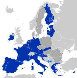
Deutsch: Eurozone
Staaten, die den Euro de jure angenommen haben Staaten und Gebiete, die den Euro de facto angenommen haben EU-Mitglieder außerhalb der Eurozone English: Eurozone
Countries using the Euro de jure Countries and territories using the Euro de facto EU member states that are outside the Eurozone Français : Zone euro
Pays ayant adopté l'euro de jure Pays et territoires utilisant l'euro de facto États membres de l'Union européenne n'ayant pas adopté l'euro Hrvatski: Eurozona
Članice Eurozone Države koje koriste Euro kao sredstvo plaćanja, ali su izvan Eurozone i Europske unije (Kosovo i Crna Gora) Članice Europske unije koje su izvan Eurozone Latviešu: Eirozona
Valstis, kuras izmanto eiro de jure Valstis un teritorijas, kuras izmanto eiro de facto Eiropas savienības dalībvalstis ārpus eirozonas Polski: Strefa Euro
Kraje używające Euro de jure Kraje i terytoria używające Euro de facto Członkowie Unii Europejskiej będący poza strefą Euro Português: Zona Euro
Países que adotaram de jure o euro Países e territórios que utilizam de facto o euro Estados-membros da União Europeia que não adotaram o euro Српски / srpski: Еврозона
Чланице еврозоне Државе и области, које користе Евро као средство плаћања, али су ван Еврозоне и Европске уније (Црна Гора и Косово) Чланице Европске уније, које су ван Еврозоне Українська: Єврозона
Країни, що використовують Євро де-юре Країни та території, що використовують Євро де-факто Країни-члени ЄС за межами єврозони فارسی: منطقه یورو
کشورهایی که یورو را به طور رسمی پذیرفتهاند کشورها و مناطقی که از یورو به عنوان وسیله پرداخت استفاده می کنند اما عضو منطقه یورو نیستند کشورهای عضو اتحادیه اروپا که خارج از منطقه یورو هستند |
| Fecha | |
| Fuente | Europe countries.svg |
| Autor | Glentamara |
| SVG desarrollo |
Licencia
| Yo, el titular de los derechos de autor de esta obra, lo libero al dominio público. Esto aplica en todo el mundo. En algunos países esto puede no ser legalmente factible; si ello ocurriese: Concedo a cualquier persona el derecho de usar este trabajo para cualquier propósito, sin ningún tipo de condición al menos que éstas sean requeridas por la ley. |
Historial de l'image
Puncha en la data/hora per a vore l'image tal i com es mostrava en eixe moment.
| Data/Hora | Miniatura | Dimensions | Usuari | Descripció | |
|---|---|---|---|---|---|
| actual | 23:39 31 dec 2025 | | 450 × 456 (417 kB) | Ahonc | Bulgaria joined eurozone |
Enllaços a l'image
Les següents pàgines enllacen ad esta image: