
Archiu:Cv-map.png
No es dispon d'una resolució més alta.
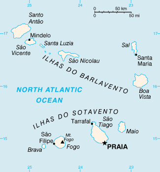
Cv-map.png ((325 × 350 pixels, tamany de l'archiu: 8 kB, MIME tipo: image/png))
Summary
Español: Mapa Político
CIA map of Cape Verde
This image is in the public domain because it contains materials that originally came from the United States Central Intelligence Agency's World Factbook.
|
 |
Historial de l'image
Puncha en la data/hora per a vore l'image tal i com es mostrava en eixe moment.
| Data/Hora | Miniatura | Dimensions | Usuari | Descripció | |
|---|---|---|---|---|---|
| actual | 04:55 12 feb 2022 | | 325 × 350 (8 kB) | wikimediacommons>Lojwe | Cropped 2 % horizontally, 1 % vertically using CropTool with precise mode. |
Enllaços a l'image
No n'hi ha pàgines que enllaçen a esta image.