

Archiu:DaylightSaving-World-Subdivisions.png
Tamany d'esta vista prèvia: 800 × 355 píxels. Atres/s resolucions: 320 × 142 píxels | 640 × 284 píxels | 1024 × 454 píxels | 1280 × 568 píxels | 2560 × 1136 píxels | 4952 × 2197 píxels.
Resolució completa. ((4952 × 2197 pixels, tamany de l'archiu: 464 kB, MIME tipo: image/png))

|
This law-related map image could be re-created using vector graphics as an SVG file. This has several advantages; see Commons:Media for cleanup for more information. If an SVG form of this image is available, please upload it and afterwards replace this template with
{{vector version available|new image name}}.It is recommended to name the SVG file “DaylightSaving-World-Subdivisions.svg”—then the template Vector version available (or Vva) does not need the new image name parameter. |
Summary
| Description |
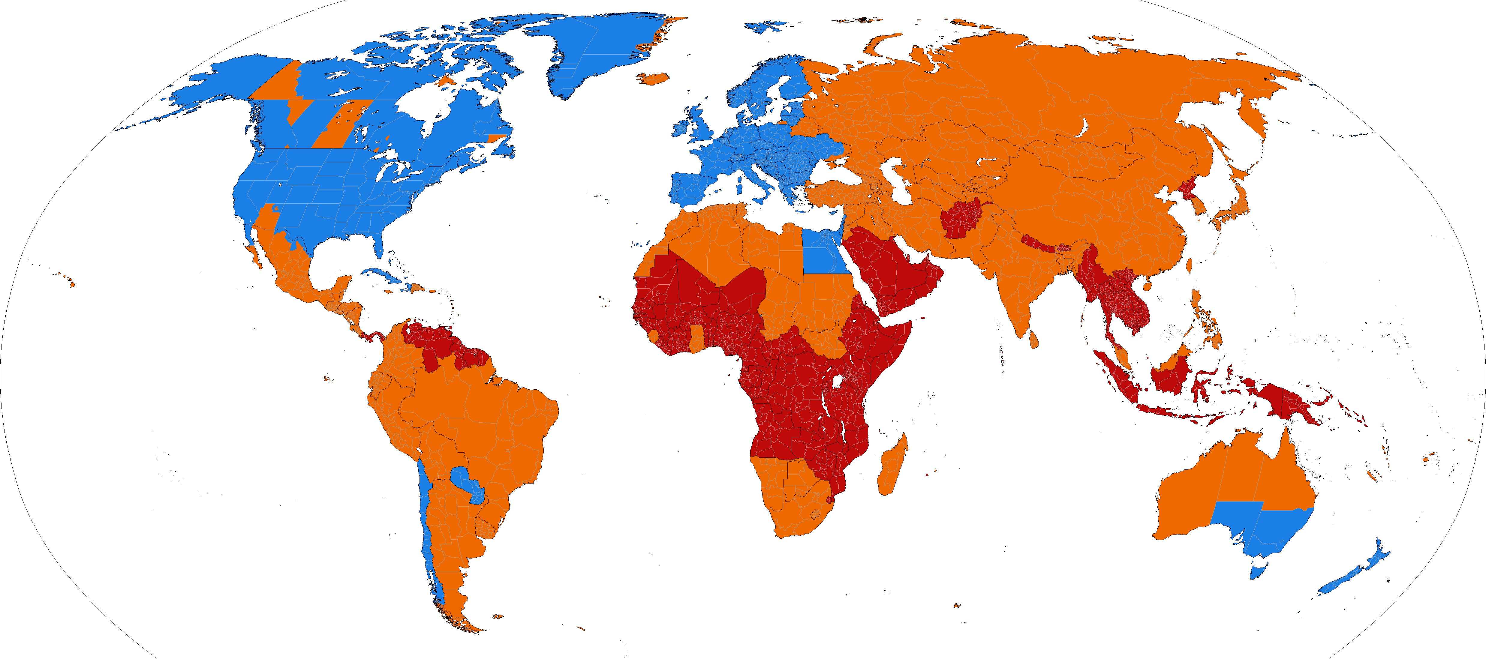
Bahasa Indonesia: Peta dunia yang menunjukkan wilayah yang masih menggunakan Waktu Musim Panas maupun yang (sudah) tidak menggunakannya.
Waktu Musim Panas masih digunakan.
Waktu Musim Panas sudah tidak digunakan.
Waktu Musim Panas tidak pernah digunakan. Català: Horari d'estiu.
S'utilitza el canvi d'hora.
Ja no s'utilitza el canvi d'hora.
Mai no s'ha utilitzat el canvi d'hora. Čeština: Aktuální a dřívější využívání letního času.
Využívá se letní čas.
Letní čas se už nevyužívá.
Letní čas se nikdy nevyužíval. Deutsch: Aktuelle und frühere Verwendung der Sommerzeit auf der Welt.
Sommerzeit benutzt.
Sommerzeit nicht mehr benutzt.
Sommerzeit nie benutzt. English: World map showing current and past daylight saving time usage. The Spring-forward/Fall-back adjustment is a common practice at high latitudes.
DST is used.
DST is no longer used.
DST has never been used. Español: Horario de verano en el mundo.
Se utiliza el cambio horario.
Ya no se utiliza el cambio horario.
Nunca se ha utilizado el cambio horario. Français : Carte du monde montrant l’utilisation actuelle et passée de l’heure d’été. Les changements aux règles de l’heure d’été ou les découvertes à propos des erreurs dans les données historiques peuvent nécessiter des modifications de l’image. Régions utilisant l’heure d’été.
Régions qui n’utilisent plus l’heure d’été.
Régions n’ayant jamais utilisé l’heure d’été. Italiano: Ora Legale.
Stati che adottano l’ora legale.
Stati che hanno utilizzato l'ora legale in passato.
Stati in cui non vi è mai stata l'ora legale. Nederlands: Zomertijd.
Gebieden die zomertijd gebruiken.
Gebieden die geen zomertijd meer gebruiken.
Gebieden die nooit zomertijd hebben gebruikt. Polski: Czas letni.
Obszary, które przyjęły czas letni.
Obszary, które kiedyś przyjęły czas letni, ale obecnie z niego nie korzystają.
Obszary, na których nigdy nie wprowadzono czasu letniego. Português do Brasil: Mapa mundial mostrando o atual e antigo uso do horário de verão. Alterações às regras do horário de verão, ou descobertas sobre erros nos dados históricos, devem requerir alterações à imagem. O horário de verão é usado.
O horário de verão não é mais usado.
O horário de verão nunca foi usado. Română: Harta lumii ilustrand statele care folosesc, au folosit, sau nu au folosit ora de vara. "Schimbarile regulilor legate de ora de vara sau descoperirile legate de erorile strecurate in datele istorice ar presupune modificari ale imaginii. Unde se foloseste ora de vara.
Unde nu se mai foloseste ora de vara in prezent.
Unde nu s-a folosit niciodata ora de vara. Scots: Warld cairt showin current an past daylicht savin time uisage. The Ware-forward/Hairst-back adjustment is a common practice at haich latitudes. Changes tae DST rules, or discoveries aboot errors in historical data, would require changes tae the image. DST is uised.
DST is no longer uised.
DST haes never been uised. Suomi: Kartta kesäajan käytöstä maailmanlaajuisesti. Kellojen siirto on yleisempää korkeammilla leveysasteilla.
Kesäaika on käytössä.
Kesäaika on joskus ollut käytössä.
Kesäaika ei ole koskaan ollut käytössä. Svenska: Karta som visar nutida respektive tidigare användande av sommartid, fördelat på stat.
Sommartid används.
Sommartid används ej längre.
Sommartid har aldrig använts. Русский: Карта мира, показывающая использование перехода на летнее время (DST) сейчас и в прошлом.
DST используется.
DST больше не используется.
DST никогда не использовалось. Українська: Карта світу, що демонструє використання "Літнього часу" зараз та в минулому.
Використовується літній час.
Припинилось використання літнього часу.
Літній час ніколи не використовувався. ქართული: მსოფლიოს რუქა, რომელიც აჩვენებს ზაფხულის დროის გამოყენებას. გაზაფხულის-წინ/შემოდგომის-უკან გადასვლა ჩვეულებრივი ამბავია მაღალ განედზე. ცვლილებები ზაფხულის დროის წესებში ან შეცდომების აღმოჩენა ისტორიულ მონაცემებში მოითხოვს ცვლილებას სურათში. ზაფხულის დრო გამოიყენება.
ზაფხულის დრო აღარ გამოიყენება.
ზაფხულის დრო არ გამოიყენებოდა არასდროს. עברית : מפה שמציגה את אימוץ שעון הקיץ במדינות שונות בעולם.
מדינות ואזורים המנהיגים שעון קיץ
מדינות ואזורים שהנהיגו בעבר שעון קיץ
מדינות ואזורים שלא הנהיגו שעון קיץ מעולם العربية :
تستعمل التوقيت الصيفي.
لم تعد تستعمل التوقيت الصيفي.
لم تستعمل التوقيت الصيفي مطلقاً. |
| Date | |
| Source | based on Image:BlankMap-World-Subdivisions.PNG, plus the data in the tz database, plus data in the maps on the INMS's Time Zones & Daylight Saving Time page. |
| Author | Paul Eggert |
| Other versions |
Supplementary map: |

Licensing

|
Permission is granted to copy, distribute and/or modify this document under the terms of the GNU Free Documentation License, Version 1.2 or any later version published by the Free Software Foundation; with no Invariant Sections, no Front-Cover Texts, and no Back-Cover Texts. A copy of the license is included in the section entitled GNU Free Documentation License. |
| This file is licensed under the Creative Commons Attribution-Share Alike 3.0 Unported license. | ||
| ||
| This licensing tag was added to this file as part of the GFDL licensing update. |
Historial de l'image
Puncha en la data/hora per a vore l'image tal i com es mostrava en eixe moment.
| Data/Hora | Miniatura | Dimensions | Usuari | Descripció | |
|---|---|---|---|---|---|
| actual | 19:21 8 març 2026 | Sense miniatura | 4952 × 2197 (464 kB) | wikimediacommons>Heitordp | Corrected southeast British Columbia, updated Ukraine, reduced file size |
Enllaços a l'image
Les següents pàgines enllacen ad esta image: