
Archiu:Germanic tribes (750BC-1AD).png
No es dispon d'una resolució més alta.
Germanic_tribes_(750BC-1AD).png ((537 × 376 pixels, tamany de l'archiu: 10 kB, MIME tipo: image/png))
.png)
Summary

|
File:Germanic tribes settlements 750BC-1AD.svg is a vector version of this file. It should be used in place of this PNG file when not inferior.
File:Germanic tribes (750BC-1AD).png → File:Germanic tribes settlements 750BC-1AD.svg
For more information, see Help:SVG. |
 |
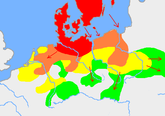
| Description |
English: Based on p. 108 in the Penguin Atlas of World History, volume 1, from the Beginning to the Eve of the French Revolution. 1988. ISBN 0-14-051054-0. Note that the map assumes that the Nordwestblock was Germanized before 500 BC. This is uncertain; alternative proposals hold that the area near the mouths of the Rhine came under a Germanic superstate only in the 1st century BC.
The map is drawn on en:User:Dbachmann's blank map: en:Image:Europe plain rivers.png Settlements before 750 bc
New settlements by 500 bc
New settlements by 250 bc
New settlements by ad 1
Archived copy of a version of the original map. |
| Date | 21 January 2007 (original upload date) |
| Source | Transferred from en.wikipedia to Commons. |
| Author | Berig at English Wikipedia |
see also Image:Pre Migration Age Germanic.png
Licensing
I, Berig, the copyright holder of this work, hereby publishes it under the following licenses:

|
Permission is granted to copy, distribute and/or modify this document under the terms of the GNU Free Documentation License, Version 1.2 or any later version published by the Free Software Foundation; with no Invariant Sections, no Front-Cover Texts, and no Back-Cover Texts. A copy of the license is included in the section entitled GNU Free Documentation License. |
| This file is licensed under the Creative Commons Attribution-Share Alike 3.0 Unported license. | ||
Attribution:
I, Berig | ||
| ||
| This licensing tag was added to this file as part of the GFDL licensing update. |
This file is licensed under the Creative Commons Attribution 2.5 Generic license.
Attribution:
I, Berig
- You are free:
- to share – to copy, distribute and transmit the work
- to remix – to adapt the work
- Under the following conditions:
- attribution – You must give appropriate credit, provide a link to the license, and indicate if changes were made. You may do so in any reasonable manner, but not in any way that suggests the licensor endorses you or your use.
You may select the license of your choice.
Original upload log
The original description page was here. All following user names refer to en.wikipedia.
- 2007-01-21 10:52 Berig 537×376×8 (18448 bytes) Based on p. 108 in the Penguin Atlas of World History, volume 1, from the Beginning to the Eve of the French Revolution. 1988. The map is drawn on [[User:Dbachmann]]'s blank map: [[:Image:Europe plain rivers.png]]
Historial de l'image
Puncha en la data/hora per a vore l'image tal i com es mostrava en eixe moment.
| Data/Hora | Miniatura | Dimensions | Usuari | Descripció | |
|---|---|---|---|---|---|
| actual | 00:34 17 feb 2009 | | 537 × 376 (10 kB) | wikimediacommons>Disposable.Heroes | pngcrush |
Enllaços a l'image
No n'hi ha pàgines que enllaçen a esta image.
.png)