

Archiu:Occitania blanck map.PNG
No es dispon d'una resolució més alta.
Occitania_blanck_map.PNG ((573 × 397 pixels, tamany de l'archiu: 10 kB, MIME tipo: image/png))

|
This linguistic map image could be re-created using vector graphics as an SVG file. This has several advantages; see Commons:Media for cleanup for more information. If an SVG form of this image is available, please upload it and afterwards replace this template with
{{vector version available|new image name}}.It is recommended to name the SVG file “Occitania blanck map.svg”—then the template Vector version available (or Vva) does not need the new image name parameter. |
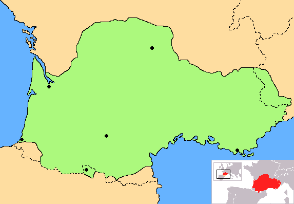
Summary
| Description | Correct map of Occitania, with geographic context and remarking of the country borders |
| Date | |
| Source | Own work |
| Author | Norrin strange |
| Other versions | Derivative works of this file: Occitania aranes map.png |
I, the copyright holder of this work, hereby publish it under the following licenses:

|
Permission is granted to copy, distribute and/or modify this document under the terms of the GNU Free Documentation License, Version 1.2 or any later version published by the Free Software Foundation; with no Invariant Sections, no Front-Cover Texts, and no Back-Cover Texts. A copy of the license is included in the section entitled GNU Free Documentation License. |
| This file is licensed under the Creative Commons Attribution-Share Alike 3.0 Unported license. | ||
| ||
| This licensing tag was added to this file as part of the GFDL licensing update. |
You may select the license of your choice.
Historial de l'image
Puncha en la data/hora per a vore l'image tal i com es mostrava en eixe moment.
| Data/Hora | Miniatura | Dimensions | Usuari | Descripció | |
|---|---|---|---|---|---|
| actual | 18:30 27 jun 2023 | | 573 × 397 (10 kB) | wikimediacommons>Jfblanc | Improved boundaries |
Enllaços a l'image
Les següents pàgines enllacen ad esta image: